The Buckeye Trail
The Adventure...
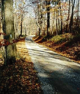
Follow the Blue Blazes! A trail that connected the Ohio River to Lake Erie was first envisioned in the late 1950s. Today, the Buckeye Trail covers nearly 1,444 miles as it loops around the state, winding through some of Ohio’s most spectacular natural areas. The trail is marked by 2” wide by 6” long blue blazes on trees and poles. Hikers can experience the whole trail or can select a variety of shorter hikes. Four sections of the trail – the Stockport, New Straitsville, Old Man’s Cave, Scioto Trail, Sinking Spring Sections – traverse Morgan, Athens, Vinton, and Pike Counties taking visitors through some of the trail’s most picturesque areas and historic places.
Learn More!
PO Box 254
Worthington, Ohio 43085
330.340.3824 (General Trail Information)
740.585.2603 (Stockport Section)
614.270.1661 (New Straitsville Section)
740.385.0074 (Old Man’s Cave Section)
937.834.2891 (Scioto Trail Section)
937.289.2481 (Sinking Spring Section)
Website: www.buckeyetrail.org
E-Mail: [email protected]
Getting there is Half the Adventure!
The 1,444 mile long trail winds around Ohio. The New Straitsville section runs through northern Athens County across parts of Burr Oak State Park, Trimble Wildlife Area, and Wayne National Forest. The Old Man’s Cave Section runs through the northwestern corner of Vinton County across the Salt Creek and through Tar Hollow State Forest. While the Scioto Trial and Sinking Spring Sections cross western Pike County through Pike Lake State Park and Pike State Forest. Check the Buckeye Trail Web Site for access points.
Click HERE to View the Map
Click HERE to View the Map
